







Top-Top Info Worldwide is a popular online newsportal and going source for technical and digital content for its influential audience around the globe.

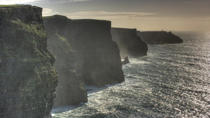
Cliffs are not simply high walls of rock. They are boundaries produced by uplift, faulting, glaciers, waves, rivers, and erosion, often acting in combination. Rankings by “height” can be misleading because sources measure from different starting points and disagree about what counts as vertical. These ten landscapes are presented for geological and cultural variety rather than as a definitive tallest-to-shortest list.
Layers of sandstone, siltstone, and shale expose sediments formed more than 300 million years ago. Atlantic waves attack the base while weather weakens the upper rock, producing caves, stacks, and periodic collapse. The official site warns visitors to stay on marked paths and away from unstable edges.
Molokaʻi’s north shore rises dramatically above the Pacific. National Park Service geologists describe a huge flank collapse, followed by erosion and later volcanic activity, as central to the landscape’s formation. Kalaupapa is also a place of living community and painful history connected to the forced isolation of people with Hansen’s disease.
This broad rock platform stands above Lysefjord in a landscape shaped by glaciation. The famous viewpoint requires a substantial hike over uneven terrain. Norwegian guidance stresses weather checks, suitable clothing and footwear, honest assessment of ability, and willingness to turn back.
Along the Great Australian Bight, long limestone cliffs mark the edge of the Nullarbor Plain. Horizontal layers record ancient marine environments, while powerful Southern Ocean waves continue to reshape the coast. Designated lookouts provide safer views than informal approaches to the rim.
This volcanic sea cliff rises steeply above Madeira’s southern coast. A developed viewpoint makes the scale accessible, but its glass platform and road access should not distract from the island’s volcanic origin and the agricultural terraces fitted into demanding terrain below.
Chalk cliffs on the Normandy coast contain arches, headlands, and a needle-like stack. Waves and weather exploit fractures in the chalk, while harder flint bands create visible dark lines. Tides can cut off beach routes, so visitors should consult local access information before walking below the cliffs.
The northern end of Viðoy presents a steep basalt face to the North Atlantic. Repeated lava flows, glacial shaping, and marine erosion contribute to the scenery. Fog, wind, wet ground, and exposed routes make local guidance essential for hikers.
In Auyuittuq National Park on Baffin Island, Mount Thor is known for an exceptionally steep rock face. This is remote Arctic terrain, not a roadside viewpoint. Travel requires planning around weather, river crossings, wildlife, communications, and park procedures, often with experienced local operators.
Colored sedimentary layers form escarpments and intricate erosional features across northern Arizona. Some sought-after areas use permit systems to limit damage and manage safety. Heat, scarce water, flash floods, and difficult navigation can be more important than the apparent steepness of a photograph.
Granite towers and adjacent sedimentary rocks in Patagonia were exposed and sharpened by uplift and glacial erosion. Rapid weather changes and strong winds shape every visit. Official park rules protect fragile vegetation and require travelers to use authorized campsites and trails.
A cliff’s drama comes from active processes, not frozen scenery. The safest and most respectful viewpoint is usually the one established by the people who manage the landscape.
Sources: Cliffs of Moher official geology guide; National Park Service: Kalaupapa Geology; Visit Norway: Preikestolen Safety; National Natural Landmarks Program.
Beauty is personal, and “castle” covers structures built for very different purposes. Some were fortresses; others were palaces designed to project legitimacy, stage court life, or create a romantic fantasy of the past. This selection is not a universal ranking. It highlights ten places that reward attention to architecture, landscape, and preservation.
Himeji’s white plastered walls, layered roofs, gates, and twisting approaches combine visual unity with defense. UNESCO identifies it as the finest surviving example of early seventeenth-century Japanese castle architecture. Its timber construction and 82 surviving buildings make the complex far richer than its famous main keep alone.
This Crusader-period fortress was developed in stages and later modified under Mamluk control. Concentric defenses, towers, halls, and its commanding location show how architecture responded to changing warfare. Syria’s conflict has also made conservation and accurate damage assessment part of the site’s modern story.
Set on volcanic rock above the city, Edinburgh Castle combines a defensible position with centuries of royal, military, and national symbolism. Buildings from different periods reveal continual adaptation rather than one perfect medieval design. Its prominence demonstrates how landscape can become part of political architecture.
Commissioned by King Ludwig II in the nineteenth century, Neuschwanstein is not a medieval fortress. It is a historicist retreat inspired by earlier architecture, theater, legend, and music. UNESCO added Ludwig’s palace group to the World Heritage List in 2025, recognizing their carefully staged artistic worlds and period technology.
Rising above the meeting of two rivers, the Alcázar reflects medieval origins and repeated remodeling. Its pointed roofs and cliff-edge silhouette are memorable, but the building’s importance also comes from its changing functions as royal residence, fortress, prison, and military academy.
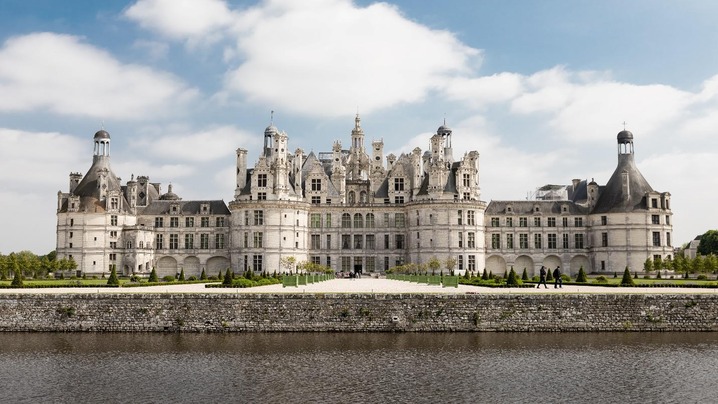
Chambord expresses Renaissance royal ambition through a vast plan, richly modeled roofline, and celebrated double-helix staircase. Although it borrows defensive forms, it was designed principally for status and residence rather than sustained siege warfare. The surrounding estate is integral to the experience.
Prague Castle is a large precinct rather than a single building. Palaces, churches, courtyards, and fortifications accumulated over centuries, with St. Vitus Cathedral dominating the skyline. The ensemble shows how a seat of rule can evolve while remaining central to a city’s identity.
Elmina is architecturally imposing, but describing it only as beautiful would erase its role in the Atlantic slave trade. Built by the Portuguese and later controlled by the Dutch and British, it confined enslaved Africans before forced transportation. Visiting requires attention to testimony, violence, and memory.
Massive walls rise above Jodhpur, enclosing gates, courtyards, palaces, and museum collections. Fine stone carving contrasts with the fortress’s scale. The site illustrates how defensive architecture and elite domestic display could coexist within one complex.
The Teutonic Order’s brick complex expanded into a monumental fortified monastery and administrative center. Its scale and restoration history make it important for understanding both medieval power and modern conservation. Rebuilding after wartime destruction is part of what visitors see today.
Castles endure because later generations continually decide what to preserve and how to interpret it. Their strongest stories combine visual impact with honest history.
Sources: UNESCO: Himeji-jo; UNESCO: Palaces of Ludwig II; UNESCO: Segovia; UNESCO: Ghana forts and castles; UNESCO: Malbork.

A ranking of the “most dangerous cities” promises a simple answer to a complicated question. In practice, such lists can stigmatize millions of residents while giving travelers little useful guidance. Crime is uneven within cities, official records are not perfectly comparable, and a rate from one year can change quickly. The responsible approach is to understand what a statistic measures and what it leaves out.
Intentional homicide is more consistently defined and more likely to be recorded than crimes such as theft or assault. Analysts often calculate a rate per 100,000 residents so places with different population sizes can be compared. The United Nations Office on Drugs and Crime maintains city-level and national datasets using the International Classification of Crime for Statistical Purposes.
Even homicide data require care. Administrative boundaries may cover a compact central municipality in one country and a much larger metropolitan area in another. Population estimates can lag rapid migration. Some datasets use police records, others public-health records, and conflict-related deaths may be classified separately. A list that mixes years, boundaries, or sources can produce a precise-looking but unreliable order.
A citywide rate says little about when, where, and among whom violence occurs. Risk may be concentrated in a small number of neighborhoods or connected to organized crime, domestic violence, political unrest, or other specific contexts. Residents, commuters, and short-term visitors can face very different patterns of exposure. Meanwhile, travelers may be more likely to encounter road crashes, scams, theft, extreme weather, or gaps in medical care than homicide.
Crime reporting also reflects public trust and institutional capacity. A higher recorded rate for some offenses can indicate better reporting rather than more victimization. Conversely, low figures may hide underreporting. This is why comparisons should disclose the offense definition, source, time period, geographic boundary, population denominator, and known data limitations.
A transparent dataset can help researchers study trends and allocate prevention resources. It cannot establish that every part of one city is more dangerous than every part of another. Nor does a ranking explain why violence occurs or which interventions work. The World Health Organization treats homicide as part of a broader preventable burden of injury and violence, emphasizing data collection, victim services, legislation, and multi-sector prevention.
For travelers, the useful question is not “Where does this city rank?” but “What risks are current, where are they concentrated, and what precautions apply to my itinerary?” For residents and policymakers, the focus should be on evidence-based prevention rather than a label that can discourage investment and deepen stereotypes. City safety deserves context, current data, and respect for the people behind the numbers.
Sources: UNODC city-level homicide data; UNODC Global Study on Homicide; WHO homicide indicator metadata; WHO injuries and violence fact sheet; U.S. State Department crime guidance.

Lists of the world’s “most dangerous airports” are irresistible, but they often confuse a visually dramatic approach with a poor safety record. A short runway beside mountains may demand specialized procedures while operating safely under strict limits. A large, ordinary-looking airport may face more runway conflicts simply because it handles enormous traffic. Risk is not a single property that can be read from a photograph.
Terrain is the most visible factor. Mountains, valleys, water, and dense development can constrain approach paths or leave little room for runway safety areas. Weather adds another layer: strong crosswinds, rapidly changing visibility, high elevation, heat, snow, or standing water can affect aircraft performance. Runway length and slope matter, but only in relation to aircraft weight, wind, temperature, surface condition, and required safety margins.
Airfield layout also matters. Intersecting runways, complex taxiways, and closely spaced entrances can increase the chance of a runway incursion—the incorrect presence of an aircraft, vehicle, or person on a protected runway surface. The FAA’s risk programs therefore examine geometry and event data, not merely runway size. At busy airports, technology such as surface surveillance and runway status lights can give pilots and vehicle operators an additional warning when a runway is occupied.
Meaningful comparisons require consistent denominators and definitions. Should an airport be judged by accidents per flight, serious incidents, weather diversions, runway excursions, or the difficulty reported by pilots? Small airports may have too few annual flights for stable rates. Reporting quality also differs among states. Combining historic accidents with current infrastructure creates another distortion: airports change runways, procedures, navigation aids, aircraft restrictions, and emergency services over time.
Some airports commonly featured in viral lists are no longer operating, while others permit only certain aircraft or specially qualified crews. That does not make them tourist attractions to fear. It means operators and regulators recognize hazards and control exposure. The International Civil Aviation Organization’s runway-safety framework emphasizes coordinated, data-driven action by airports, airlines, air navigation services, regulators, and investigators.
Passengers usually do not need to assess runway geometry themselves. Commercial operators must comply with applicable aircraft, crew, weather, and airport requirements. For trip planning, check the airline’s notices, official airport status, and government travel guidance. Weather disruption and schedule reliability may be more relevant to a traveler than an airport’s dramatic setting.
The honest conclusion is less thrilling than a countdown: some airports are unusually demanding, but challenge and danger are not synonyms. Safety is best understood through current operational restrictions, incident data, and the defenses in place—not through recycled superlatives.
Sources: ICAO Global Runway Safety Action Plan; FAA Airport Safety; FAA Runway Safety Areas; FAA Takeoff and Landing Performance Assessment; FAA Runway Status Lights.
Top-Top Info Worldwide is a popular online newsportal and going source for technical and digital content for its influential audience around the globe.