








Top-Top Info Worldwide is a popular online newsportal and going source for technical and digital content for its influential audience around the globe.


With a population of just around 70,000 people, Portland residents balance urban hipness with a streak of rugged adventure. With homes in the $200,000 range, this middle-class town allows its residents to live the work-hard/play-hard lifestyle.

This forest thrives on Mount Fuji; located in Japan. The entire range of forest sits on hardened lava which was a result of the last major eruption of the Mt Fuji that dates back to 864 CE.
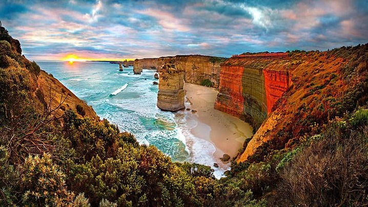
A sea stack is an isolated pillar of rock near a coast, usually left behind as waves exploit cracks in a headland. Caves can enlarge into arches; when an arch roof collapses, a stack remains offshore. The sequence is a useful model, not a timetable: rock type, joints, storms, currents, and local geology produce different shapes and rates of change. These ten examples are snapshots in landscapes that are still evolving.
Victoria’s famous limestone stacks rise beside the high-energy Southern Ocean. Despite the name, there were never twelve standing together. Parks Victoria explains that caves and arches formed as the coast retreated, leaving pillars that continue to erode. One stack collapsed dramatically in 2005, demonstrating that permanence is an illusion here.
This tall sandstone stack stands off Hoy in Orkney. Its form reflects erosion along weaknesses in layered rock. It is also a celebrated climbing objective, but exposed conditions and nesting wildlife make it a place for experienced climbers operating within local guidance, not casual scrambling.
At Downpatrick Head in County Mayo, Dún Briste is a flat-topped stack cut off from the mainland. Horizontal rock layers make its structure especially visible. Local tradition gives the formation cultural meaning, while geology records repeated marine erosion along Ireland’s Atlantic edge.
Dark basalt stacks stand offshore from Reynisfjara on Iceland’s south coast. Folklore describes petrified trolls, while the rocks themselves belong to a volcanic landscape reshaped by the sea. The beach is also known for dangerous sneaker waves. Visitors should obey closures and remain far from the water, even in apparently calm conditions.
Ball’s Pyramid is a steep volcanic remnant southeast of Lord Howe Island. Rather than a typical fragment of a retreating sedimentary cliff, it is the exposed residue of an ancient volcanic system. Its isolation supports unusual ecology, including the conservation story of the Lord Howe Island stick insect.
Known locally as León Dormido, this eroded volcanic formation rises from waters near San Cristóbal in the Galápagos. A channel divides its main masses. The setting is biologically sensitive, so access and wildlife encounters should follow Galápagos National Park rules and authorized-tour guidance.
This red sandstone pillar stands near Heligoland in the North Sea. Waves, salt, weather, and fractures continue to weaken it. Viewing from designated paths is safer than approaching unstable cliff edges, and it reduces trampling in a small, heavily visited coastal environment.
The “Giant and the Witch” are two stacks off Eysturoy. Their names come from a Faroese legend, an example of how communities turn conspicuous landforms into memorable stories. The rock towers are best understood from safe shore viewpoints rather than as fixed objects guaranteed to endure.
Haystack Rock at Cannon Beach is part of the Oregon Islands National Wildlife Refuge. Its intertidal pools and seabird habitat are as important as its outline. Seasonal protections, leash rules, and tide awareness help visitors avoid disturbing nesting birds or becoming trapped by incoming water.
Standing below the Cliffs of Moher, Branaunmore was once connected to the cliff line. The site’s alternating sandstone, siltstone, and shale layers respond differently to erosion. Official guidance emphasizes staying on marked paths because the cliffs are active and collapses can occur without warning.
Sea stacks inspire wonder because they make deep time visible. Their fragility is not a flaw; it is the central fact of the landscape.
Sources: Parks Victoria; UNESCO: Lord Howe Island Group; U.S. Fish and Wildlife Service; Cliffs of Moher official geology guide.

Pyramids appear in several ancient societies, but similarity of shape does not prove a shared origin. A broad base supports height efficiently, making a tapering form a practical solution for monumental building. The structures below had different functions, materials, dates, and religious meanings. Seeing those differences is more revealing than treating every pyramid as a variation on Egypt.
Built at Giza during Egypt’s Old Kingdom, Khufu’s pyramid was the center of a royal funerary complex that included temples, causeways, smaller pyramids, and cemeteries. Its scale reflects centralized administration, quarrying, transport, surveying, and a large skilled workforce. Archaeological evidence does not support the popular claim that enslaved outsiders alone built it.
At Saqqara, Djoser’s monument developed the earlier mastaba tomb form into a stepped stone pyramid. The surrounding ceremonial complex made architecture part of royal ritual. It is important not simply as a “first,” but as evidence of experimentation in large-scale stone construction.
Dahshur preserves two major projects associated with Sneferu. The Bent Pyramid changes angle partway up, while the Red Pyramid achieves a more consistent smooth-sided form. Together they show engineering knowledge developing through construction rather than appearing fully perfected.
Kushite rulers and elites built steep-sided funerary pyramids in the region of Meroe over many centuries. Their proportions, chapels, and cultural setting differ from Old Kingdom Egyptian monuments. They belong to an African civilization with its own political and artistic history, even as Kush interacted with Egypt and the wider Nile Valley.
The Napatan region includes pyramids, tombs, temples, palaces, and burial chambers associated with the kingdom of Kush. UNESCO emphasizes more than two millennia of religious and political significance. Current conflict in Sudan makes protection of people and heritage an urgent concern.
Teotihuacan became one of the largest cities in the ancient Americas. Its Pyramid of the Sun anchors an urban plan of avenues, plazas, temples, compounds, and infrastructure. The names now used for its major monuments came from later peoples; much about the city’s language and rulers remains uncertain.
This stepped temple, often called El Castillo, formed part of a Maya city with architecture reflecting regional exchange and changing political power. Popular claims about exact astronomical effects should be checked against archaeological authorities, because modern demonstrations and crowd traditions can outrun the evidence.
Tikal’s tall temple-pyramids rose above a major Maya city in the rainforest. Temple I combined dynastic commemoration, burial, and sacred architecture. Its steep stairway was not designed as a modern visitor route, and climbing restrictions protect both people and ancient masonry.
Palenque integrated pyramid platforms, vaulted buildings, sculpture, and inscriptions. The Temple of the Inscriptions contained the tomb of ruler K’inich Janaab’ Pakal. Deciphered Maya texts have transformed interpretation by restoring names, dates, and political histories once hidden by colonial misunderstanding.
Caral’s monumental platform structures belong to one of the earliest urban traditions in the Americas. They differ in form and function from Egyptian tomb pyramids and later Maya temples. Their planned plazas and buildings demonstrate organized communal life in the Supe Valley thousands of years ago.
Pyramids are powerful evidence of human planning, belief, and labor. Their shared geometry is an invitation to compare societies carefully, not to collapse them into one imaginary civilization.
Sources: UNESCO: Memphis and its Necropolis; UNESCO: Gebel Barkal; UNESCO: Teotihuacan; UNESCO: Sacred City of Caral-Supe.
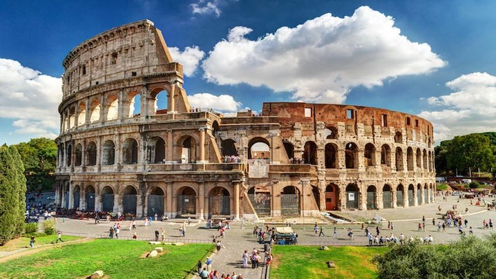
Ancient Roman monuments are more than photogenic ruins. They show how an empire moved water, staged public life, projected authority, honored the dead, and connected distant provinces. No single list can represent a civilization that extended across three continents, but these ten places offer a useful cross-section. They also remind visitors that “Roman” history belongs to many modern countries and communities, not only to the city of Rome.
Opened in the first century CE, the Flavian Amphitheatre hosted spectacles before enormous crowds. Its stacked arcades, circulation passages, and numbered entrances demonstrate sophisticated crowd management. The building also confronts visitors with the violence built into imperial entertainment, including gladiatorial combat and executions.
This connected archaeological landscape was the political and ceremonial center of ancient Rome. Temples, basilicas, triumphal arches, and government buildings accumulated over centuries. Above the Forum, elite residences on the Palatine reveal how closely political power and privileged domestic life could overlap.
The Pantheon’s concrete dome remains a landmark in architectural history. Its circular interior, coffered ceiling, and central oculus create an unusually unified space. Although rebuilt under Emperor Hadrian, the façade retained an inscription naming Marcus Agrippa. Later use as a church helped the structure survive in far more complete condition than many ancient buildings.
Buried during the eruption of Vesuvius in 79 CE, Pompeii preserves streets, houses, shops, bath complexes, political notices, and wall paintings. Its value lies less in any single monument than in the unusually detailed view it provides of an urban community, including enslaved people, workers, traders, women, and children.
This three-tiered bridge carried an aqueduct across the Gardon River as part of a system supplying ancient Nîmes. The structure illustrates how Roman surveyors and builders managed gradients, water flow, heavy masonry, and flood conditions over a long route.
Built across northern Britain beginning in the reign of Hadrian, the frontier included forts, milecastles, roads, and settlements as well as the wall itself. It was not an impermeable national border. It functioned as a controlled military zone shaped by soldiers and civilians drawn from different parts of the empire.
Roman Augusta Emerita became a major administrative center in Lusitania. Its theatre, amphitheatre, bridge, aqueduct remains, and urban plan show how architecture helped reproduce Roman civic institutions far from Italy.
Leptis Magna flourished on the North African coast and received major building projects under Septimius Severus, who was born there. Its forum, basilica, market, harbor, and streets challenge the mistaken idea that Roman monumental culture was principally European.
The sanctuary complex at Baalbek incorporated exceptionally large stonework and monumental temples built over a long period. Its architecture reflects Roman imperial forms while also belonging to a much older regional sacred landscape in the Bekaa Valley.
Begun in 312 BCE and extended over time, the Appian Way linked Rome with southern Italy. Surviving pavement, bridges, tombs, villas, and roadside remains make it possible to read a transportation system as a cultural landscape rather than as a single structure.
The most compelling Roman monuments are not necessarily the largest. They are the places where engineering, daily life, ideology, and later reuse remain visible together.
Sources: UNESCO: Historic Centre of Rome; UNESCO: Pompeii and Herculaneum; UNESCO: Pont du Gard; UNESCO: Via Appia.
Top-Top Info Worldwide is a popular online newsportal and going source for technical and digital content for its influential audience around the globe.